If you want to know which trees, plants and flowers will grow best on your property, start with understanding planting zones for your NJ landscape.
Beautiful gardens don’t just happen. They take lots of planning and care. And part of planning is knowing which plants and flowers will grow best on your property.
There’s a reason we don’t see palm trees thriving in New Jersey. However, not all landscape decisions are that obvious.
Know Your Planting Zone
Knowing a planting zone allows you to know which plants won’t just survive but will thrive on your property.
Professional landscapers always take planting zones into account when designing a garden or total landscape.
The two best sources of planting zone information for New Jersey are the US Department of Agriculture (USDA) Plant Hardiness Zone Map and the Canadian Planting Zone Map.

USDA Plant Hardiness Zone Map
Many consider the USDA Plant Hardiness Zone Map to be the US gold standard for guiding tree, shrub, and perennial choices for your garden. It’s based on the lowest winter temperatures.
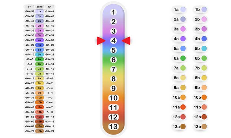
There are 13 different zones. Each of the zones represents an area where the lowest winter temperature falls within a specific 10 degrees range.
Each zone is further divided into two sub-zones, “a” and “b.” The sub-zones have 5° temperature variations.
- Zone 1 is the coldest, with temperature averages reaching a chilling -60° F
- Zone 13 is the warmest, with average minimum winter temperature possibly dipping to a balmy 60° F
The current USDA map, created in 2012, uses temperatures from data spanning the years 1976-2005.
The map is very easy to use. All zones are color coded. Map designers listed temperatures in both Fahrenheit° and Celsius°.
Each of these zones has been carefully mapped by the PRISM Climate Group of Oregon State University with the Agricultural Research Service of the USDA.
What are the Hardiness Zones for New Jersey?
Take a minute to view the New Jersey portion of the USDA Plant Hardiness Zone Map and find your county and location.
The 4 New Jersey zones—6a, 6b, 7a, and 7b—range from coldest to less cold.
For example, it’s easy to find the zones for the following counties:
- Essex County – zones 6b and 7a
- Sussex – zone 6a
- Union – zones 7a and 6b
- Somerset – zone 6b
- Morris – zones 6a and 6b
When you purchase a plant, it’s usually marked with a hardiness zone number. Using the right zone for your area will give you the best results.
To add interest to your NJ landscape, you can check out these exotic trees that may grow well in your zone.
But what if you’re buying annuals for your garden? A similar Canadian mapping system takes other climate factors into consideration.

Canadian Planting Zone Map by Natural Resources Canada (NRC)
The NRC in Canada produces a Canadian Planting Zone Map.
Some gardeners find this information more helpful than the USDA map because it considers other climate variables, including the length of a growing season, how much rainfall to expect, and dates of first and last frosts.
The formula used to develop the different Canadian zones is complex. Just a few of the measurements it uses includes:
- Monthly mean of daily minimum temperatures of the coldest month
- Amount of rainfall from June to November
- Mean of daily maximum temperatures of warmest month
Mean maximum snow depth
How Planting Zones Help Your Landscape
The USDA guide is most helpful for selecting trees, shrubs, plants, and flowers that will live through the winter months.
It’s important to keep plants in their appropriate zone.
For example, if you live in Sussex County, NJ, and fall into zone 6a, don’t purchase plants that thrive in a zone 7a or even 6b. There may be only a 5° or 10° difference between these two zones, but it can mean the difference between a bountiful flower bed in the spring, or winter-damaged perennials with few blossoms.
The Canadian planting zones are helpful for seeds, annuals, and vegetable garden crops because of the information it provides for the growing season.
When you’re planting annuals, you don’t need to be concerned with winter statistics. The annuals won’t survive the first frost.
Canada vs. US zones–How to Use Both
So, how can New Jerseyans benefit from information on the NRC map?
It’s easy.
Experts say, simply add one zone to your USDA zone to get your Canadian zone. For example, USDA zone 7 is equal to Canada’s zone 8. Then look up Canadian zone 8 for helpful growing information for your region.

What is a Microclimate?
Within each planting zone, there are microclimates. A microclimate is a small area that varies from the norm in the zone.
It can be created by several factors including:
- A steep change in elevation
- Being near water
- Amount of sunlight that reaches the ground
A microclimate can be warmer or cooler. If all or part of your property is in a microclimate, you can possibly successfully grow something that is otherwise outside of your growing zone.
For example, a microclimate can exist in a garden that has one spot that gets a lot of sun. Or a heavily shaded spot may exist in an otherwise sunny location.
Professional gardeners use microclimates to design attractive and unusual gardens.
USDA Map history
Researchers developed the first USDA Plant Hardiness Map in 1960. The current map, first published in 2012, incorporates climate data from the prior 30 years. It incorporates additional information regarding terrain, elevation, and proximity to bodies of water.
How Is Climate Change Affecting Plant Hardiness Zones?
The Yale School of Education reports that plant hardiness zones are being affected by climate change. In the US, zones are moving northward at the rate of 13 miles per decade if you compare the two published USDA Plant Hardiness Map.
Researchers who created the 2012 UADA map say detailed mapping techniques, and better measurement of climate temperatures explain these zone shifts. More research should provide important clarification.
Sponzilli Landscape Group can create the perfect, unique garden that will thrive in your growing zone. Contact us today to find out what your beautiful landscape can look like.

